
|
|
| DEUTSCHLAND | GERMANY |
| Bundesland: Freistaat Bayern | Bavaria |
| Regierungsbezirk: Oberbayern | |
| Landkreis: Berchtesgadener Land |
map →

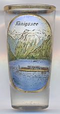
 The Königssee, literally 'King's Lake', is situated at an elevation of 603 m
in the extreme south east of the German State of Bavaria, near the German-Austrian Border,
about 8 km south of the district town Berchtesgaden.
The lake is part of the municipality Schönau a. Königssee. Also part of Schönau
is the popular pilgrimage church St. Bartholomä, located on a peninsula on the western
shore of the lake.
The Königssee, literally 'King's Lake', is situated at an elevation of 603 m
in the extreme south east of the German State of Bavaria, near the German-Austrian Border,
about 8 km south of the district town Berchtesgaden.
The lake is part of the municipality Schönau a. Königssee. Also part of Schönau
is the popular pilgrimage church St. Bartholomä, located on a peninsula on the western
shore of the lake.
The lake was formed by glaciers during the last ice age and measures 7.7 kilometers long and is about 1.7 kilometers at its widest point. With a maximum depth of 190 m, the Königssee is the deepest lake in Germany. Since 1909 electric boats operate on the lake; the oldest boat of the 17 that currently are in operation was built in 1920.
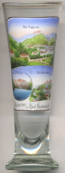
Glass no. 4516 [right] is a souvenir from Bad Reichenhall but also shows a view of the Königssee in the bottom left picture (but using the outdated spelling Königsee) as well as a view of Berchtesgaden in the bottom right picture.
Another place with an almost identical name, Königsee (note: only one 's'), is depicted on
glass no. 2134 of this collection.
![[scale]](lineal.jpg)