
|
|
| DEUTSCHLAND | GERMANY |
| Bundesland: Freistaat Bayern | Bavaria |
| Regierungsbezirk: Oberbayern | |
| Landkreis: Berchtesgadener Land |
map →

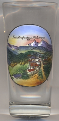
 Berchtesgaden is situated at an elevation of 572 m in the centre of the district Berchtesgadener Land, of which it is the administrative centre.
The municipality has a population of about 7,700 (2020).
Berchtesgaden is situated at an elevation of 572 m in the centre of the district Berchtesgadener Land, of which it is the administrative centre.
The municipality has a population of about 7,700 (2020).
The first ever historical note dates back to 1102 and mentions the area because of its rich salt deposits. Much of Berchtesgaden's wealth has been derived from its salt mines, the first of which started operations in 1517. The town served as independent prince-provostry (Fürstpropstei) until the Reichsdeputationshauptschluss in 1803. During the Napoleonic wars, Berchtesgaden changed hands a few times, such as in 1805 under the Treaty of Pressburg (Bratislava), when the area was ceded to Austria. Berchtesgaden came under Bavarian rule in 1810 and became instantly popular with the Bavarian royal family, the House of Wittelsbach, who often visited Königssee and maintained a royal hunting residence in the former Augustine monastery. Nascent tourism started to evolve and a number of artists came to the area, which reportedly gave rise to 'Malereck' ("painters' corner") on the shore of Königssee in nearby Ramsau bei Berchtesgaden. Adolf Hitler had been vacationing in the Berchtesgaden area since the 1920s. He purchased a home in the Obersalzberg above the town on the flank of the Hoher Goll and began extensive renovations on his Berghof in the following years. After the war, Berchtesgaden became a military zone and most of its buildings were requisitioned by the U.S. Army. In 1972, local government reform united the then independent municipalities of Salzberg, Maria Gern and Au (consisting of Oberau and Unterau) under the administration of the town of Berchtesgaden.
The  Watzmann (2,173 m, on the picture on glass no. 4199 given as 2,714 m), depicted in the background, is
the third-highest mountain in Germany and the highest located entirely on German territory. Three main peaks array on a north–south axis along a
ridge on the mountain's taller western half: Hocheck (2,651 m), Mittelspitze (Middle Peak, 2,713 m) and Südspitze
(South Peak, 2,712 m). The Watzmann massif also includes the 2,307 m Watzmannfrau (Watzmann Wife, also known as Kleiner Watzmann
or Small Watzmann), and the Watzmannkinder (Watzmann Children), five lower peaks in the recess between the main peaks and the Watzmannfrau. The
entire massif lies inside Berchtesgaden National Park.
Watzmann (2,173 m, on the picture on glass no. 4199 given as 2,714 m), depicted in the background, is
the third-highest mountain in Germany and the highest located entirely on German territory. Three main peaks array on a north–south axis along a
ridge on the mountain's taller western half: Hocheck (2,651 m), Mittelspitze (Middle Peak, 2,713 m) and Südspitze
(South Peak, 2,712 m). The Watzmann massif also includes the 2,307 m Watzmannfrau (Watzmann Wife, also known as Kleiner Watzmann
or Small Watzmann), and the Watzmannkinder (Watzmann Children), five lower peaks in the recess between the main peaks and the Watzmannfrau. The
entire massif lies inside Berchtesgaden National Park.
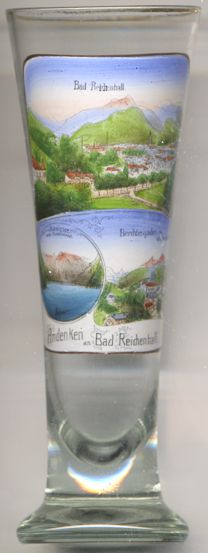
Glass no. 4516 [right] is a souvenir from Bad Reichenhall but also shows
a view of the Königssee in the bottom left picture as well as a view
of Berchtesgaden in the bottom right picture.
[https://de.wikipedia.org/wiki/Berchtesgaden, https://en.wikipedia.org/wiki/Berchtesgaden]
![[scale]](lineal.jpg)