
|
|
| ÖSTERREICH | AUSTRIA |
| Bundesland: Salzburg | |
| Bezirk: Zell am See |
map →
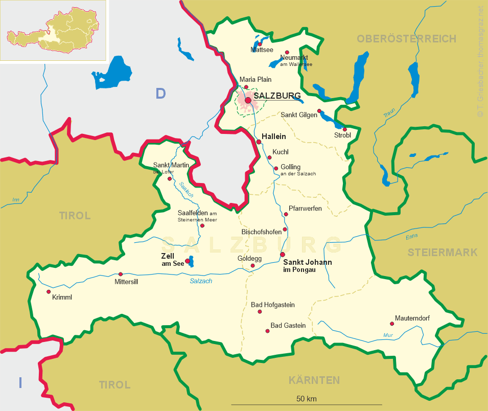
Mittersill is situated at an elevation of 790 m in the upper Salzach valley, approximately 25 km west of the district town Zell am See and 27 km east of the start of the Salzach Valley in Krimml. Mittersill straddles the Salzach River and one of its tributaries; the Felber. The town is bordered to the south by the Hohe Tauern mountain range, and to the north by the Kitzbühel Alps. The municipality has a population of about 5,400 (2011).
In winter Mittersill is a popular destination for sports such as skiing, snowboarding, and sledding. Mittersill has a connection with the Kitzbühel ski area through the newly built Panoramabahn cable car. It allows access to the Resterhöhe ski area, which in turn is connected to the ski areas of Kirch and the Hahnenkamm at Kitzbühel by the 3S Aerial Tramway; a structure with the largest span of its type in the world. Mittersill is also close to other well-known ski resorts such as Zell am See, Kaprun, and the Zillertal Arena. In summer Mittersill has an 18-hole golf course and acts as a gateway to the Hohe Tauern National Park with its newly built visitor centre. Popular summer activities include hiking, mountain biking, and paragliding.
 There is evidence of a settlement in the Mittersill area during the Bronze Age in around 2200 BC. Mittersill itself was first founded in the
11th century as a part of Bavaria. Its castle was built in the middle of the next century. Mittersill fell under the control of the archbishopric of
Salzburg in the 13th century and the castle became the seat of the archbishops in Upper Pinzgau. By 1357 Mittersill had a
market town charter conferred upon it by the Salzburg Archbishop Ortolf, which boosted the town's profile considerably. By the 14th century it was
acting as an important trade crossroads with salt, ice, and copper being taken south over the Felbertauern Pass (2,481m) to Southern Tyrol and Friuli
in northeastern Italy. Goods such as wine, fruits, velvet, and silks came north over the pass to be taken into present-day Austria and Germany.
In the 1525 Peasant's War, Mittersill castle was burned down and subsequently rebuilt, giving it the appearance that can be seen today.
In 1635 and 1746 the town itself was struck by fire and most of the medieval marketplace was destroyed as a result.
Mittersill became linked to Zell am See in 1898 and Krimml along the Salzach Valley with the opening
of the Pinzgau Lokalbahn train service, which still operates today.
A military school for an aerial tramway was founded in Mittersill in 1939. A subcamp of the Mauthausen concentration camp was
located here during World War II. Construction work for a goods cable car across the mountain range started in 1943. Part of this cable car included
two supports, each 280 m high; one was built of steel, the other was constructed of wood (the tallest ever in this material). As a result of the war,
this aerial cable car could not be completed and both pillars were demolished in the 1950s. On August 8, 2008 Mittersill received city rights.
There is evidence of a settlement in the Mittersill area during the Bronze Age in around 2200 BC. Mittersill itself was first founded in the
11th century as a part of Bavaria. Its castle was built in the middle of the next century. Mittersill fell under the control of the archbishopric of
Salzburg in the 13th century and the castle became the seat of the archbishops in Upper Pinzgau. By 1357 Mittersill had a
market town charter conferred upon it by the Salzburg Archbishop Ortolf, which boosted the town's profile considerably. By the 14th century it was
acting as an important trade crossroads with salt, ice, and copper being taken south over the Felbertauern Pass (2,481m) to Southern Tyrol and Friuli
in northeastern Italy. Goods such as wine, fruits, velvet, and silks came north over the pass to be taken into present-day Austria and Germany.
In the 1525 Peasant's War, Mittersill castle was burned down and subsequently rebuilt, giving it the appearance that can be seen today.
In 1635 and 1746 the town itself was struck by fire and most of the medieval marketplace was destroyed as a result.
Mittersill became linked to Zell am See in 1898 and Krimml along the Salzach Valley with the opening
of the Pinzgau Lokalbahn train service, which still operates today.
A military school for an aerial tramway was founded in Mittersill in 1939. A subcamp of the Mauthausen concentration camp was
located here during World War II. Construction work for a goods cable car across the mountain range started in 1943. Part of this cable car included
two supports, each 280 m high; one was built of steel, the other was constructed of wood (the tallest ever in this material). As a result of the war,
this aerial cable car could not be completed and both pillars were demolished in the 1950s. On August 8, 2008 Mittersill received city rights.
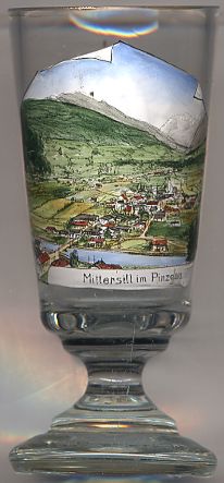
The  parish church Sankt Leonhard [background right]
originally dates from the 13th century, but has later additions, such as a 1420 stone sculpture of St. Leonard, a Baroque façade and onion dome,
and an 18th-century high altar in Rococo style.
parish church Sankt Leonhard [background right]
originally dates from the 13th century, but has later additions, such as a 1420 stone sculpture of St. Leonard, a Baroque façade and onion dome,
and an 18th-century high altar in Rococo style.
[Texts adapted from http://en.wikipedia.org/wiki/Mittersill]
![[scale]](lineal.jpg)