
|
|
| DEUTSCHLAND | GERMANY |
| Bundesland: Freistaat Bayern | Bavaria |
| Regierungsbezirk: Oberbayern | |
| Landkreis: Berchtesgadener Land |
map →

 Schneizlreuth is situated at an elevation of 511 m in the Berchtesgadener Land district of southeast Upper Bavaria, about 7 km southwest
of the district town, Bad Reichenhall, and about 17 northwest of Berchtesgaden. The municipality of Schneizelreuth
has a population of about 1,300 (2012).
Schneizlreuth is situated at an elevation of 511 m in the Berchtesgadener Land district of southeast Upper Bavaria, about 7 km southwest
of the district town, Bad Reichenhall, and about 17 northwest of Berchtesgaden. The municipality of Schneizelreuth
has a population of about 1,300 (2012).
The earliest known written mention of Schnaezenreut dates from 1285. The modern municipality was formed in 1909 by merging the formerl independent municipalities of Jettenberg and Ristfeucht, the latter with the hamlet Schneizlreuth. The neighbouring municipality of Weißbach an der Alpenstraße and parts of the unincorporated forest area Karlsteiner Forst were incorporated into Schneizlreuth in 1978. Parts of the Jettenberger Forst were incorporated into Schneizlreuth in 1984, followed in 2011 by the incorporation of the Forst St. Zeno.
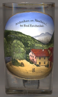
The country inn, today hotel,  Mauthäusl goes back to a tavern founded around 1650 and originally served waggoners who
transported salt and wood and who had to pay a toll at this place for using the road that connected the old Tyrolean Imperial Road (Tiroler Reichsstraße) via
the Cleber pass to Weißenbach. This road had been constructed in 1597–1599 and replaced the much older road over the Jochberg pass which had aready been used
around 15 BC.
Mauthäusl goes back to a tavern founded around 1650 and originally served waggoners who
transported salt and wood and who had to pay a toll at this place for using the road that connected the old Tyrolean Imperial Road (Tiroler Reichsstraße) via
the Cleber pass to Weißenbach. This road had been constructed in 1597–1599 and replaced the much older road over the Jochberg pass which had aready been used
around 15 BC.
[https://de.wikipedia.org/wiki/Schneizlreuth; http://www.hotel-mauthaeusl.de]
![[scale]](lineal.jpg)