
|
|
| SLOVENSKO | SLOVAKIA |
| Žilinský kraj | Žilina region |
| okres: Žilina |
map →
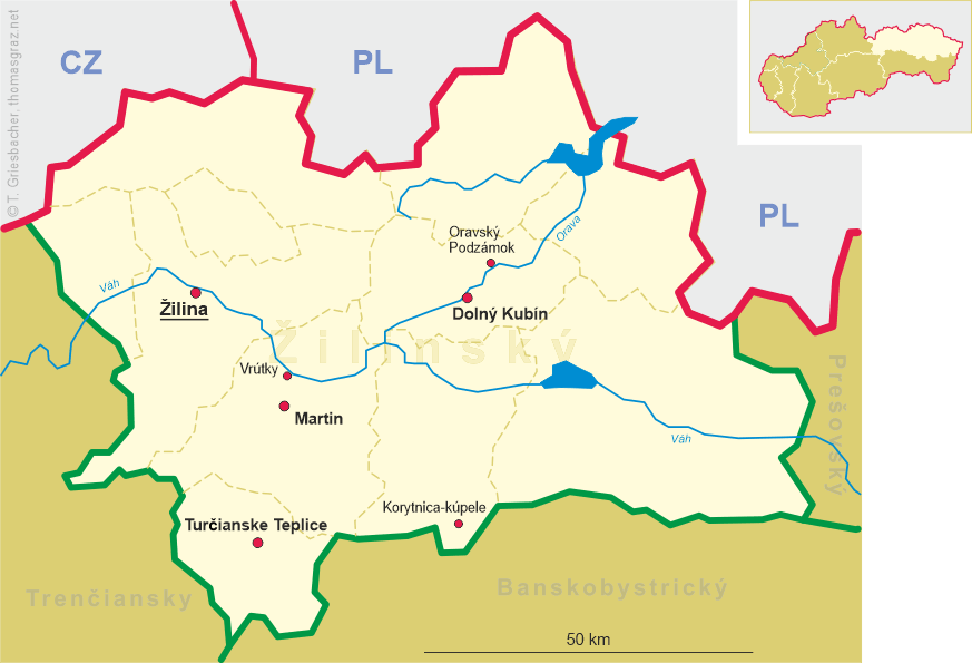
 Žilina is situated at an elevation of 342 m on the river Váh in the Žilina basin (Žilinská kotlina).
Žilina is the capital of the homonymous region (Žilinský kraj) and is the seat of the district (okres) Žilina.
The municipality has a population of about 81,300 (2013).
Žilina is situated at an elevation of 342 m on the river Váh in the Žilina basin (Žilinská kotlina).
Žilina is the capital of the homonymous region (Žilinský kraj) and is the seat of the district (okres) Žilina.
The municipality has a population of about 81,300 (2013).
The area was inhabited already in the late Stone Age (about 20,000 BC). Slavs started to move into the area in the 5th century AD. The first written reference to Žilina was in 1208 as terra de Selinan. From the second half of the 10th century until 1918, it was part of the Kingdom of Hungary. The city started to develop around 1300, and according to records in 1312 it was already a town. In 1321, King Charles I of Hungary (Károly Róbert) made Žilina a Free Royal Town. The city boomed in the second half of the 19th century as new railway tracks were built: the Kassa–Oderberg Railway was finished in 1872 and the railway to Bratislava in 1883, and new factories started to spring up. It was one of the first municipalities to sign the Martin Declaration (30 October 1918; mentioning the "the Slovak branch of the unified Czecho-slovak nation"), and until March 1919 it was the seat of the (temporary) Slovak government within the Czechoslovak Republic. On 6 October 1938, shortly after the Munich Agreement, the autonomy of Slovakia within Czechoslovakia was declared in Žilina. Today Žilina is the third largest city in Slovakia, the third most important industrial center and the seat of a university (founded in 1953). The historical center of the city, reconstructed in the early 1990s is protected as a city monument reserve.
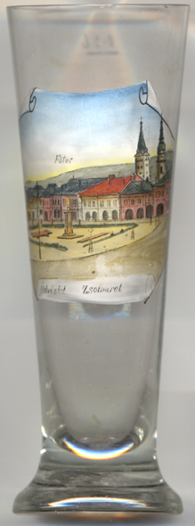
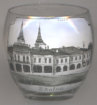
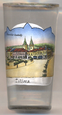
Glasses no. 4930 [above left], no. 3692 [near left] and no. 2980
[right] show views of the  main
main
The Church of the Holy Trinity [background], since February 2008 Holy Trinity Cathedral (colloquially in Slovak Farský kostol,
meaning Parish church) is the Roman Catholic cathedral of the Žilina diocese. The church was built around 1400 and was originally dedicated to St. Mary,
but in the 16th century it was reconsecrated as the Church of the Holy Trinity (kostol Najsvätejšej Trojice). The chapel of John of
Nepomuk was added in 1762.
The church burned down three times, in 1678, 1848 and partly in 1886. The three naves of the church were originally in Gothic style, but after a reconstruction it was
remodeled in Renaissance style. The last major reconstruction of the church was done in 1942. The right one of the two towers depicted on the glass is Burian's tower,
separate from the church, created in the 16th century.
[https://de.wikipedia.org/wiki/Žilina, https://en.wikipedia.org/wiki/Žilina;
https://en.wikipedia.org/wiki/Czechoslovakism;
https://en.wikipedia.org/wiki/Church_of_the_Holy_Trinity,_Žilina]
![[scale]](lineal.jpg)