
|
|
| ÖSTERREICH | AUSTRIA |
| Bundesland: Niederösterreich | Lower Austria |
| Bezirk: Sankt Pölten |
map →

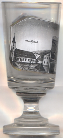
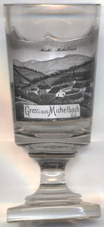
 Michelbach is situated at an elevation of 376 m in the southeast of the district Sankt Pölten
in the Mostviertel region of Lower Austria. The municipality consists of the settlements Finsteregg, Gstetten, Kleindurlas, Kropfsdorf,
Mayerhöfen, Michelbach Dorf, Michelbach Markt and Untergroin, organised in the cadastral districts Mayerhöfen, Michelbach Dorf
and Michelbach Markt. The municipality has a population of 856 (2021).
Michelbach is situated at an elevation of 376 m in the southeast of the district Sankt Pölten
in the Mostviertel region of Lower Austria. The municipality consists of the settlements Finsteregg, Gstetten, Kleindurlas, Kropfsdorf,
Mayerhöfen, Michelbach Dorf, Michelbach Markt and Untergroin, organised in the cadastral districts Mayerhöfen, Michelbach Dorf
and Michelbach Markt. The municipality has a population of 856 (2021).
Michilpach was first mentioned in a document of the bisphopric of Passau dating from 1124, referring to the creation of an independent parish. Michelbach suffered heavily during the First and Second Sieges of Vienna (1529 and 1683), and also was hit severly by the plagues of 1541, 1574 and 1583. The almost depopulated region was resettled in the early 18th century.
The
[https://de.wikipedia.org/wiki/Michelbach_(Nieder%C3%B6sterreich);
https://de.wikipedia.org/wiki/Liste_der_denkmalgesch%C3%BCtzten_Objekte_in_Michelbach_(Nieder%C3%B6sterreich)]
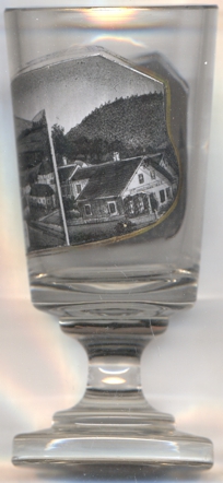
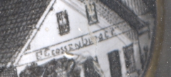 The building depicted on the right picture of glass no. 4032 bears the inscription F. GROSSENBERGER.
![[scale]](lineal.jpg) contact: webmaster
contact: webmaster