
|
|
| ČESKÁ REPUBLIKA | CZECH REPUBLIC |
| Zlínský kraj | Zlín region |
| Okres: Uherské Hradiště |
map →
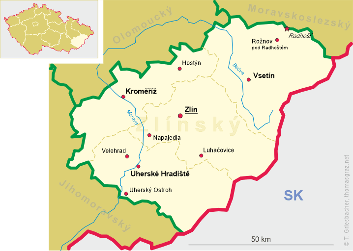
 Uherské Hradiště is situated at an elevation of 179 m on the Morava river, about 23 km southwest of the regional
capital, Zlín. The municipality has a population of about 25,000 (2021).
Uherské Hradiště is situated at an elevation of 179 m on the Morava river, about 23 km southwest of the regional
capital, Zlín. The municipality has a population of about 25,000 (2021).
A predecessor of Uherské Hradiště was a settlement and fortification system on three islands in the Morava river, founded by Slavic tribes in the 8th and early 9th century. The settlement disappeared after the fall of the Great Moravian Empire in the early 10th century. The modern settlement, originally named Nový Veligrad, was founded in 1257 by King Přemysl Otakar II to protect the nearby monastery in Velehrad. The name later changed to Hradiště (litterally 'fortified settlement'). The modern name, Uherské Hradiště ('Hungarian Hradiště') was used for the first time in 1587. Stone walls replaced the original wooden palisades in the 14th century. In the following centuries, the fortifications were continuously improved. Due to its location, Uherské Hradiště repeatedly faced raids. The town was threatened by the Cumans in the 16th century, by military clashes during the Thirty Years' War (1618–1648), or by Turkish invasions during the Austro-Turkish War (1716–1718). The town was not conquered until 1742 by the Prussian Army. From 1644 to 1773, the Jesuits acted in the town. Their work increased the cultural and spiritual life of the town. The order founded a complex of buildings which included the Jesuit college, the church of Saint Francis Xavier and the Jesuit school. In the 1780s, Uherskě Hradiště ceased to function as a fortress and in the mid-19th century the town began to expand beyond the walls. The town continued to grow in the 19th century, when many representative buildings were constructed, and in the early 20th century, when industrial companies were founded.
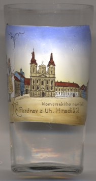
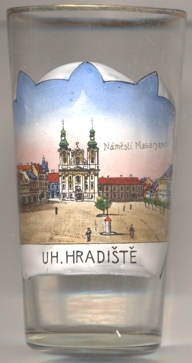
The Baroque  church of St. Francis Xavier [left, no. 4131, and right, no. 4431: centre]
was built in 1670–1685 together with the Jesuit college [background right].
church of St. Francis Xavier [left, no. 4131, and right, no. 4431: centre]
was built in 1670–1685 together with the Jesuit college [background right].
On glass, no. 3131 [left] is labeled Komenského náměstí, on glass no. 4431
[right] it is labeled Náměstí Masarykovo, which is the name used since after the creation of the Czechoslovak
Republic after World War I.
[https://de.wikipedia.org/wiki/Uhersk%C3%A9_Hradi%C5%A1t%C4%9B, https://en.wikipedia.org/wiki/Uhersk%C3%A9_Hradi%C5%A1t%C4%9B,
https://cs.wikipedia.org/wiki/Uhersk%C3%A9_Hradi%C5%A1t%C4%9B]
![[scale]](lineal.jpg)