
|
|
| DEUTSCHLAND | GERMANY |
| Bundesland: Freistaat Bayern | Bavaria |
| Regierungsbezirk: Oberbayern | |
| Landkreis: Berchtesgadener Land |
map →

The Wimbachtal (Wimbach Valley) is located in the Berchtesgaden Alps, in the heart of the
Berchtesgaden National Park in the municipality of Ramsau. Situated between the Watzmann to the
east and the Hochkalter to the west, the valley begins below the Trischübel Pass between the Watzmann and the
Steinernes Meer and soon runs steadily in a northeasterly direction. The valley is characterized by enormous debris flows,
which is why the upper part of the valley is also called Wimbachgries. The Wimbach Valley drains via the Wimbach stream,
from which it takes its name. In the upper valley, the landscape is dominated by massive scree slopes. Tributaries emerge
above ground there, but then seep into the loose material and merge underground. The stream originates in dry weather at an
elevation of approximately 800 m above sea level from several closely spaced springs in the scree, less than three
kilometers before its confluence with the Wimbach. A tributary spring provides water for a large portion of the population
in the southern part of the Berchtesgadener Land district. In its lower reaches, the Wimbach flows through the picturesque
 Wimbach Gorge. A few hundred meters after leaving the gorge, it empties into the Ramsauer Ache from the right, near the
Ramsau settlement of Wimbachbrücke. During the Ice Ages, glaciers carved out and deepened the valley. The bedrock now
lies more than 300 metres below the surface of the scree slopes that fill the valley floor. Before its accumulation of
alluvial deposits, the Wimbachgries was probably filled with a lake. Unlike the Königssee
beyond the Watzmann, which is surrounded by more stable Dachstein limestone, the Ramsau dolomite in the Wimbach valley area
offered less resistance to erosion.
Wimbach Gorge. A few hundred meters after leaving the gorge, it empties into the Ramsauer Ache from the right, near the
Ramsau settlement of Wimbachbrücke. During the Ice Ages, glaciers carved out and deepened the valley. The bedrock now
lies more than 300 metres below the surface of the scree slopes that fill the valley floor. Before its accumulation of
alluvial deposits, the Wimbachgries was probably filled with a lake. Unlike the Königssee
beyond the Watzmann, which is surrounded by more stable Dachstein limestone, the Ramsau dolomite in the Wimbach valley area
offered less resistance to erosion.
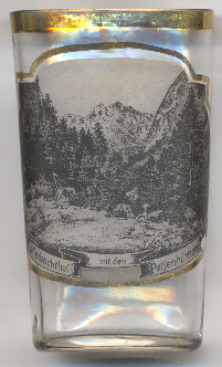
The  Palfenhörner [left, no. 4938: background], the two peaks
Kleines Palfenhorn (2,073 m) and Großes Palfenhorn (2,222 m), together with the
Seehorn (2,321 m), form a subgroup (Großes Palfenhorn in the main ridge) oriented perpendicular to
the southern Wimbach chain between Wimbachscharte and Kühleitenschneid. The Palfenhorn peaks consist of brittle Ramsau
dolomite, while the Seehorn is made of Dachstein limestone. The latter can be traversed via a marked trail, but the
Große Palfenhorn requires climbing, and the Kleine Palfenhorn even grade II. At the time, it was considered,
along with the east face of the Watzmann, the most difficult mountain climb in the Berchtesgaden Alps. To the west of the
Seehorn lies the Kallbrunnalm, one of the largest alpine pastures in the Berchtesgaden Alps.
Palfenhörner [left, no. 4938: background], the two peaks
Kleines Palfenhorn (2,073 m) and Großes Palfenhorn (2,222 m), together with the
Seehorn (2,321 m), form a subgroup (Großes Palfenhorn in the main ridge) oriented perpendicular to
the southern Wimbach chain between Wimbachscharte and Kühleitenschneid. The Palfenhorn peaks consist of brittle Ramsau
dolomite, while the Seehorn is made of Dachstein limestone. The latter can be traversed via a marked trail, but the
Große Palfenhorn requires climbing, and the Kleine Palfenhorn even grade II. At the time, it was considered,
along with the east face of the Watzmann, the most difficult mountain climb in the Berchtesgaden Alps. To the west of the
Seehorn lies the Kallbrunnalm, one of the largest alpine pastures in the Berchtesgaden Alps.
[https://de.wikipedia.org/wiki/Wimbachtal;
https://de.wikipedia.org/wiki/Hochkalter]
![[scale]](lineal.jpg)