
|
|
| DEUTSCHLAND | GERMANY |
| Bundesland: Niedersachsen | Lower Saxony |
| Landkreis: Aurich |
map →
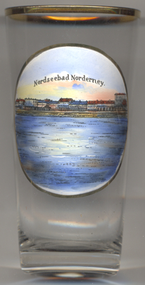
Norderney is one of the East Frisian Islands (Borkum, Memmert, Juist, Norderney, Baltrum, Langeoog, Spiekeroog and Wangerooge). The islands were formed about 2,000 years ago when the rise of the sea level after the last Ice Age had come to an end and sand was heaped up by the tides and by the wind. The islands were first mentioend in 1398. These documents mentions two islands, Burse (Buyze, Buise) and Oesterende, between Juist and Borkum. These two were the remaining parts of a former, bigger, single island, which had broken apart after many high tides during the 14th century. While the western part, Burse, gradually disappeared until 1700, the eastern part, Oesterende, began to grow. This island finally was mentioned as "Ny norderoghe", "Norderoog" or "Norder neye oog" (northern new island) in the 15th century. Until about the 16th century the modern name, Norderney, came in use.
 The first settlement on the western end of the island was founded by fishermen probably in the 13th or 14th century. They also obtained the
right to collect goods that were washed ashore from sunken ships. From the 18th century onward freight shipping also became an important
source of income for the inhabitants of the island. The first sea bath was founded already in 1797 and opened in 1800, which marked the long tradition
of Norderney as a sea-side resort. Between 1806 and 1810 Norderney was occupied by the Kingdom of Holland, and in 1810 the island
became part of the département Ems Orientale within the French Empire. The French prohibited fishing and closed the spa because they stationed some 300 soldiers
on the island in order to build a defense post against the English. When the French occupation ended in 1813 Norderney at first became part of Prussia
before it was ceded in 1815 to the Kingdom of Hannover. After that time the fishing industry and the spa began to prosper again,
but as a source of income fishing more or less ended at the end of the 19th century. The spa, however, had become one of the most popular ones in Europe
for the higher societies after the Duke of Cumberland (the crown prince of Hannover, from 1837 King Ernst August of Hannover)
had visited Norderney regularly since 1836.
From 1851 onward (under the blind King Georg V of Hannover) Norderney even was the official summer residence of the royal Hannover court.
Together with the kingdom of Hannover, Norderney was annexed by Prussia in 1866. During World War I the spa was closed and the
island was transformed into a sea fortress. In 1935 it became a military base again. In 1945 the island remained under
English military administration but a limited number of guests were already allowed to visit the island. The village of Norderney
was chartered as a town in 1948. The English occupation ended in 1952. Today the island has a population of about 6,500 permanent and about
3,600 temporary residents. Per year more than 290,000 guests visit the island.
The first settlement on the western end of the island was founded by fishermen probably in the 13th or 14th century. They also obtained the
right to collect goods that were washed ashore from sunken ships. From the 18th century onward freight shipping also became an important
source of income for the inhabitants of the island. The first sea bath was founded already in 1797 and opened in 1800, which marked the long tradition
of Norderney as a sea-side resort. Between 1806 and 1810 Norderney was occupied by the Kingdom of Holland, and in 1810 the island
became part of the département Ems Orientale within the French Empire. The French prohibited fishing and closed the spa because they stationed some 300 soldiers
on the island in order to build a defense post against the English. When the French occupation ended in 1813 Norderney at first became part of Prussia
before it was ceded in 1815 to the Kingdom of Hannover. After that time the fishing industry and the spa began to prosper again,
but as a source of income fishing more or less ended at the end of the 19th century. The spa, however, had become one of the most popular ones in Europe
for the higher societies after the Duke of Cumberland (the crown prince of Hannover, from 1837 King Ernst August of Hannover)
had visited Norderney regularly since 1836.
From 1851 onward (under the blind King Georg V of Hannover) Norderney even was the official summer residence of the royal Hannover court.
Together with the kingdom of Hannover, Norderney was annexed by Prussia in 1866. During World War I the spa was closed and the
island was transformed into a sea fortress. In 1935 it became a military base again. In 1945 the island remained under
English military administration but a limited number of guests were already allowed to visit the island. The village of Norderney
was chartered as a town in 1948. The English occupation ended in 1952. Today the island has a population of about 6,500 permanent and about
3,600 temporary residents. Per year more than 290,000 guests visit the island.
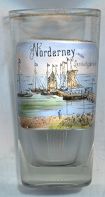
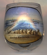
The iron  landing bridge (Landungsbrücke) [left, no. 1525] was buit in 1871 and for the first time
allowed the disembarking of passengers without the use of small boats. The landing bridge was dismantled during the winter period. A second
landing bridge, the 'Lloyd pier', for the fast liners from Hamburg and Bremerhaven was built in the 1880s.
landing bridge (Landungsbrücke) [left, no. 1525] was buit in 1871 and for the first time
allowed the disembarking of passengers without the use of small boats. The landing bridge was dismantled during the winter period. A second
landing bridge, the 'Lloyd pier', for the fast liners from Hamburg and Bremerhaven was built in the 1880s.
[https://de.wikipedia.org/wiki/Hafen_Norderney]
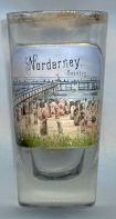
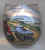
 Glasses no. 1526 [far left] and 2990 [near left] show the Sea Pier (Seesteg).
The pier was opened in 1895. It was probably the first pier that was built intirely for tourists to enjoy a promenade above the waters of the sea.
The pier's deck was situated about 2.5 metres above the sea level at high tide. The pier had a width of 4 metres and a length of 175 metres. At its end,
a secondpier, perpendicular to it, with a length of 100 metres and a width of 6 metres was constructed. Platforms of 15 by 15 metres were located at its end and in the centre.
The pier was constructed of steal. The wooden planks were dismantled in the autumn and stored suring the wintertime until they were replaced on the pier in spring.
A storehouse was built to shelter the wooden parts during the rough season. From 1926 onwards, the pier was not used any more as the shore had become to narrow and
the bathing areas had moved towards the west and north shores. The former storehouse today has been converted into a hotel (Hotel Seesteg).
Glasses no. 1526 [far left] and 2990 [near left] show the Sea Pier (Seesteg).
The pier was opened in 1895. It was probably the first pier that was built intirely for tourists to enjoy a promenade above the waters of the sea.
The pier's deck was situated about 2.5 metres above the sea level at high tide. The pier had a width of 4 metres and a length of 175 metres. At its end,
a secondpier, perpendicular to it, with a length of 100 metres and a width of 6 metres was constructed. Platforms of 15 by 15 metres were located at its end and in the centre.
The pier was constructed of steal. The wooden planks were dismantled in the autumn and stored suring the wintertime until they were replaced on the pier in spring.
A storehouse was built to shelter the wooden parts during the rough season. From 1926 onwards, the pier was not used any more as the shore had become to narrow and
the bathing areas had moved towards the west and north shores. The former storehouse today has been converted into a hotel (Hotel Seesteg).
[http://www.google.at/url?sa=t&rct=j&q=&esrc=s&source=web&cd=6&ved=0CEAQFjAF&url=http%3A%2F%2Fwww.norderney-chronik.de%2Fdownload%2Fneykurier%2F2010%2F2010-11-05.pdf&ei=6izmU5nTPKKw7Abp4oHoDQ&usg=AFQjCNGwDiGnNXgsqE2Y_VSV6BXsrrrCjg]
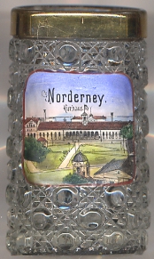
The history of the Kurhaus [left, no. 2918], also named Conversationshaus,
goes back to 1800, when the core of the building was created as a representative spa building containing a large hall, a reading room
and a billard room. Around 1815 the building was enlarged with a dining room for 100 guests and further lounges. Further additions
followed in the subsequent decades. The building was thorougly renovated in 2008.
[http://www.architekten-wdj.de/Conversationshaus_Norderney/]
The pavillon Giftbude [left, no. 2948] was opened in 1850 under the name Herrenpavillon.
However, the name Giftbude soon became popular ('Gift' actually being derived from the English word 'gift', and 'Bude' meaning small pavillon),
apparently because it had been a tradition that on two or three occasions the spa authority partly covered the cost for consumptions of the guests.
Since 1860 it operates as a restaurant.
[http://www.giftbude.de/geschichte/, http://www.giftbude.de/historie/]
![[scale]](lineal.jpg)