
|
|
| DEUTSCHLAND | GERMANY |
| Bundesland: Baden-Württemberg | |
| Regierungsbezirk: Stuttgart | |
| Landkreis: Heilbronn |
map →

Bad Friedrichshall is situated at an elevation of 155 m at the confluence of the rivers Jagst, Kocher and Neckar. The municipality of Bad Friedrichshall was created in 1934/35 by an amalgamation of the municipalities of Kochendorf, Jagstfeld and Hagenbach. The name Friedrichshall was chosen because King Friedrich I of Württemberg had ordered the first successful drillings for a salt mine in 1812–1816. The saline that was founded in 1816 had already been named Friedrichshall. The predicate "Bad" (spa) was awarded because Jagstfeld had been a saline spa in the past. In 1951 Bad Friedrichshall was officially recognized as a town. In 1972 Duttenberg was incorporated into Bad Friedrichshall, followed by Untergrießheim in 1975.
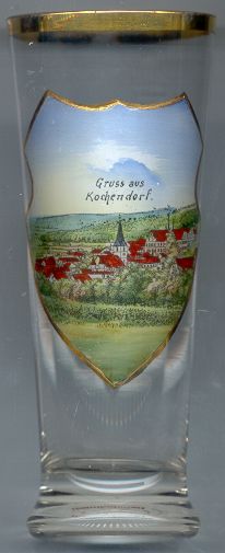
Kochendorf is situated at an elevation of 590 m just south of the river Kocher, shortly before its confluence with the river Neckar. With its 7,000 inhabitants Kochendorf is Bad Friedrichhall's largest and also historically most important town district. The settlement probably was founded in the 8th century. The first written mention dates from the year 817 and is found in a document of the monastery of Fulda. Shortly after the foundation of the royal residence in Bad Wimpfen at the beginning of the 13th century the lords of Kochendorf founded a stronghold for the protection of residence. The stronghold, however, soon fell into dereliction. Another, moated, castle of the 13th century was rebuilt as a Renaissance château (Schloss Lehen) in 1553. In 1806 Kochendorf and the other villages of the area became part of Württemberg. Ever since the opening of the saline in 1816 salt had been a major factor for the community, especially after a new salt mine had been built in the late 19th century.
A Jewish community had existed in Kochendorf since the 16th century. The first synagogue of Kochendorf was founded in the late 17th/early 18th century. The new synagogue was built in 1806, at a time when the Jewish community counted 80 people. The Jewish community was dissolved in 1925 because only 7 members were left and the synagogue was sold off.
In early 1944 a concentration camp was founded in Kochendorf. The prisoners had to work in the salt mine and in subterranean factories for the production of aurcraft turbines and railway-cars. Parts of the salt mine have been adapted as a memorial museum.
The  parish church Sankt Sebastian [centre]
was first mentioned in 1274. The east tower, the round arched windows and pillars with cushion capitals
are still remnants of this early church. The remaining parts of the church were repeatedly altered
during the following centuries. Since 1549 the church is Protestant. The building was damaged during
bomb raids in World War II. Most of the damages could be repaired and only some parts of the
interior decorations had been lost. Several tombs of the Renaissance period, and
frescos from the Gothic and Renaissance periods have survived.
parish church Sankt Sebastian [centre]
was first mentioned in 1274. The east tower, the round arched windows and pillars with cushion capitals
are still remnants of this early church. The remaining parts of the church were repeatedly altered
during the following centuries. Since 1549 the church is Protestant. The building was damaged during
bomb raids in World War II. Most of the damages could be repaired and only some parts of the
interior decorations had been lost. Several tombs of the Renaissance period, and
frescos from the Gothic and Renaissance periods have survived.
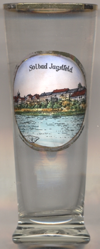
Jagstfeld originated at the "Hohe Straße" ('High Road'), an ancient trading route connecting Paris with eastern Europe. In Roman times it was situated on the western, and thus Roman, side of the limes. The Romans founded a camp village there, and since then, the place most certainly was inhabited continuously. The oldest known writen mention of the place is in the Lorsch Codex, written between 1170 and 1195, mentioning a donation in AD 768. In 976 it came into possession of the bishopric of Worms, in 1441 to the abbey of Wimpfen. In the second half of the 15th century it came in possession of the Electorate of Mainz, and in 1481 it was handed over, in exchange with other territoriy, to the Teutonic Order. After the secularisation Jagstfeld in 1805 became part of the Electorate (1806 Kingdom) of Württemberg. Since 1812 drillings for brine were successfully carried out and Jagstfeld also became known as a brine bath. In the late 19th century Jagstfeld became an important railway junction. In 1933, Jagstfeld and neighbouring Kochendorf were merged into the new municipality Bad Friedrichshall.
The picture on glass no. 4247 is labeled Solbad Jagstfeld ('brine bath Jagstfeld'), referring to the brine bath spa facilities of Jagstfeld.
![[scale]](lineal.jpg)