
|
|
| POLSKA | POLAND |
| województwo: Dolnośląskie | voivodship: Lower Silesia |
| miasto na prawach powiatu: Wałbrzych | city: Wałbrzych |
map →
Wałbrzych (German: Waldenburg) is situated at an elevation of 450 m in the Dolnośląskie (Lower Silesia) voivodship (region) of southern Poland, about 65 km southwest of the region's capital, Wrocław. Wałbrzych is the seat of the administration of the district (powiat) of the same name and has a population of about 129,500 (2004).
Wałbrzych originated around 1250 as a village next to a castle. Around 1400 it was granted a German city charter. From 1542 onward Wałbrzych was part of the Habsburg possessions. In 1742 it became part of Prussia and remained part of this country until 1945. Since 1924 the city was independent from the surrounding district, although the district administration remained in the town. Between 1975 and 1998 Wałbrzych was the capital of the Wałbrzych voivodship.
Stary Zdrój (German: Altwasser) is a city district of Wałbrzych. It was first mentioned as
Aqua Antiqua ('old water') in a document of 1357. Silver was mined here as early as 1412, coal mines are documented
since 1548. The earliest reference to mineral springs dates from 1644. Further springs discovered between 1771 and 1857
provided the basis for the popularity of Altwasser as a spa place. After 1850 Altwasser changed into an industrial town,
especially after the extension of the coal mines caused the mineral springs to run dry. Altwasser was incorporated
into Waldenburg in 1919. After World War II, Altwasser was renamed Stary Zdrój ('old spa').
The street depicted on the glass no. 2029
is
The church depicted in the background is the
Dzietrzychów (in German: Dittersbach) is situated at an elevation of 480 m in the Waldenburg
(Wałbrzych) Mountains about 2.5 km south of the centre of Wałbrzych. The city borough of
Dzietrzychów has a population of 14,000 (1945).
Dittrichsbach was first mentioned in a document dating from 1305 and was part of the duchy of Schweidnitz-Jauer
(Świdnica-Jawor). In 1364 it came in possession of the Bohemian Crown. Following the First Silesian War
(1740–1742) it became part of Prussia. In 1934, Dittersbach and the neighbouring localities of Bärengrund
and Heinrichsgrund were incorporated into the city of Waldenburg (today Wałbrzych). In 1945 it became part of
Poland and the former German population was expelled.
The place is an important railroad junction where
the railway lines Zgorzelec–Wałbrzych,
Wałbrzych–Kłodzko,
Wrocław–Wałbrzych and Wałbrzych
Szczawienko–Meziměstí meet. For this reason, the main railway station of
Wałbrzych (Wałbrzych Główny) was built here and until 1945 was named Waldenburg-Dittersbach.
At the time, the station was the second largest freight terminal in Germany. The top picture on glass no. 3783
[near left] shows a view of the
The bottom right picture on glass no. 3783 [near left] shows a view of the country inn
[https://de.wikipedia.org/wiki/Dzietrzychów]
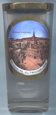
Stary Zdrój
 Charlottenbrunnerstraße, Church of the Invocation of the Resurrection of the Lord
(kościół pod wezwaniem Zmartwychwstania Pańskiego). The church was built in 1870.
The former German name of Stary Zdrój, Altwasser, was also the former German name of
Stará Voda, Czech Republic.
Charlottenbrunnerstraße, Church of the Invocation of the Resurrection of the Lord
(kościół pod wezwaniem Zmartwychwstania Pańskiego). The church was built in 1870.
The former German name of Stary Zdrój, Altwasser, was also the former German name of
Stará Voda, Czech Republic.

Dzietrzychów
viaduct Kaiser-Friedrichs-Höhe
The former German name of Dzietrzychó, Dittersbach, was also the former German name of
Dětřichov, Czech Republic.
![[scale]](lineal.jpg) contact: webmaster
contact: webmaster