
|
|
| ÖSTERREICH | AUSTRIA |
| Bundesland: Steiermark | Styria |
| Bezirk: Bruck-Mürzzuschlag |
map →

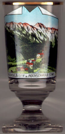 Weichselboden is situated at an elevation of 1,358 m in the valley of the river Salza at the northern
slope of the Hochschwab (2,227 m). It is a well-known area for hiking and mountain-climbing.
Until 2015, Weichselboden was part of the municipality of Gußwerk.
On 1 January 2016 Weichselboden together with Gußwerk was incoporated into the municipality of
Mariazell.
Weichselboden is situated at an elevation of 1,358 m in the valley of the river Salza at the northern
slope of the Hochschwab (2,227 m). It is a well-known area for hiking and mountain-climbing.
Until 2015, Weichselboden was part of the municipality of Gußwerk.
On 1 January 2016 Weichselboden together with Gußwerk was incoporated into the municipality of
Mariazell.
In the Hochschwab massif there are the springs for the
The  former parish church Sankt Johannes der Täufer (St. John the Baptist) [centre right]
was built in 1773–1777. The parish was dissolved and became part of the parish Gußwerk on 1 January 2001.
former parish church Sankt Johannes der Täufer (St. John the Baptist) [centre right]
was built in 1773–1777. The parish was dissolved and became part of the parish Gußwerk on 1 January 2001.
![[scale]](lineal.jpg)