
|
|
| POLSKA | POLAND |
| województwo: Pomorskie | voivodship: Pomerania |
| powiat: Człuchów | county: Człuchów |
map →
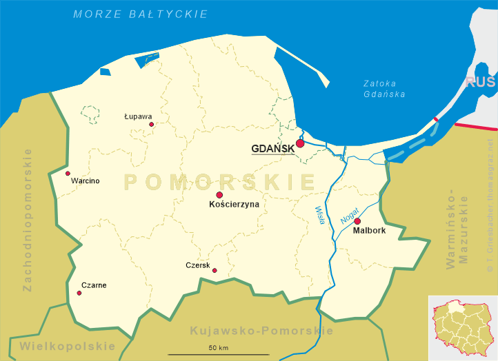
Czarne is situated at an elevation of 136 m on the left bank of the river Czarna (German: Zahne) in the midst of a large woodland area. Czarne has a population of about 6,000 (2004) and is the centre of the municipality of the same name which also encompasses the villages of Biernatka (formerly Bärenhütte), Bińcze (Bärenwalde), Domiśaw (Domslaff), Domyśl (Eggebrechtsmühle), Grabowiec (Klein Hasselberg), Janowiec (Hansfelderbrück), Kijno (Marienhof), Krzemieniewo (Krummensee), Lędyczek Drugi (Landeck II), Łoża (Loosen), Malinowo (Amalienruh), Nadziejewo (Hansfelde), Prądy (Landeckermühle), Raciniewo (Ruthenberg), Sierpowo (Breitenfelde), Sokole (Falkenwalde), Wierzbnik (Franzenhof), Wronkowo (Idashof), Wyczechy (Geglenfelde) and Wygonki (Zehnruthen).
 At the beginning of the 14th century the Teutonic order founded a small fortress called Hammerstein which protected the
crossroads of two important trading routes. Sonn after that, a settlement began to develop at this place which soon grew
to become a small town. In 1395 this settlement was granted the status of a town by the Teutonic Order and received a
charter based on the municipal rights of Kulm (now Chełmno). When the Polish king
Wladyslaw II Jagiello defeated the Teutonic Order in 1410, Hammerstein was conquered too and was handed over to
the duchy of Pomerania, which lost the town already in 1411 after the First Peace of Thorn (Toruń).
After the Second Peace of Thorn in 1466 Hammerstein (or Czarne in Polish) was incorporated into the kingdom of Poland
(Royal Prussia, which formed a personal union with Poland). Czarne became the centre of an administrative district (starost).
At the beginning of the 14th century the Teutonic order founded a small fortress called Hammerstein which protected the
crossroads of two important trading routes. Sonn after that, a settlement began to develop at this place which soon grew
to become a small town. In 1395 this settlement was granted the status of a town by the Teutonic Order and received a
charter based on the municipal rights of Kulm (now Chełmno). When the Polish king
Wladyslaw II Jagiello defeated the Teutonic Order in 1410, Hammerstein was conquered too and was handed over to
the duchy of Pomerania, which lost the town already in 1411 after the First Peace of Thorn (Toruń).
After the Second Peace of Thorn in 1466 Hammerstein (or Czarne in Polish) was incorporated into the kingdom of Poland
(Royal Prussia, which formed a personal union with Poland). Czarne became the centre of an administrative district (starost).
After the First Partition of Poland (see map) in 1772, West Prussia with Hammerstein became part of the kingdom of Prussia. The Prussian administrative reform of 1818 assigned Hammerstein to the district of Schlochau (today Człuchów). The industrialisation began especially after 1878 when Hammerstein was connected to the railroad between Neustettin (Szczecinek) and Schlochau (Człuchów). Another important economic factor in the late 19th century was the Prussian military training area which was founded in 1885. During World War I this area was used as a POW camp for Russian soldiers. After the war, the city grew due to the influx of refugees from the former eastern territories of Prussia. Between 1922 and 1938, the city was part of the province Grenzmark Posen-Westpreußen and after that part of the province Pomerania. In 1939 the Nazis founded a prison camp, to which during World War II a POW camp (Stalag II-B) was added. In February 1945 the city was conquered by the Soviet Army; about 40% of the town were destroyed during the combat operations. Since then, Czarne is again part of Poland.
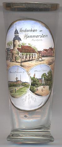
The top part of the picture on glass no. 2412 shows the market square with the
 Protestant
The two lower parts of the picture show views of the military trainig grounds:
the barracks no. 3 officers'
Glasses of this collection showing former training areas of the German Empire:
Altengrabow (D),
Arys (Orzysz, PL),
Döberitz (D),
Hagenau (Haguenau, F),
Hammelburg (D),
Hammerstein (Czarne, PL),
Heuberg (Stetten am kalten Markt, D),
Lockstedter Lager (Hohenlockstedt, D),
Münsingen (D),
Munsterlager (Munster, D),
Sennelager (Paderborn, D).
Thorn (Toruń, PL).
Warthelager (Biedrusko, PL).
[https://de.wikipedia.org/wiki/Truppenübungsplätze_(Deutsches_Reich)]
![[scale]](lineal.jpg)