
|
|
| DEUTSCHLAND | GERMANY |
| Bundesland: Nordrhein-Westfalen | North Rhine-Westphalia |
| Regierungsbezirk: Arnsberg | |
| Stadt: Herne |
map →
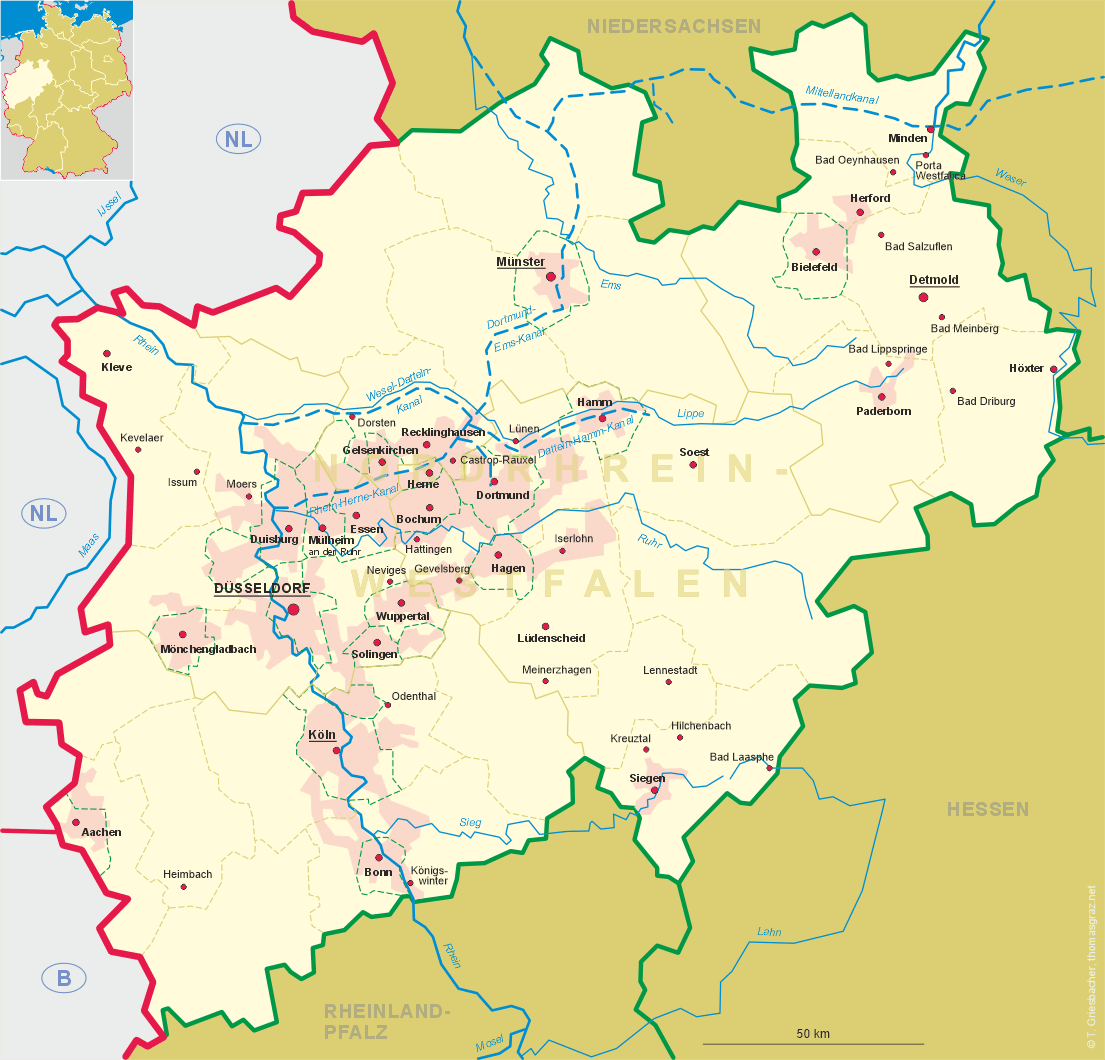
 Herne is situated at an elevation of 65 m between the cities of Bochum, Recklinghausen and Gelsenkirchen
in Germany's state of North Rhine-Westphalia.
Herne is situated at an elevation of 65 m between the cities of Bochum, Recklinghausen and Gelsenkirchen
in Germany's state of North Rhine-Westphalia.
Like most other cities in the region Herne was a tiny village until the 19th century. When the mining of coal and the production of steel began, the villages of the Ruhr area became cities. Present-day Herne includes the former cities of Herne, Wanne and Eickel. Farms bearing these names were founded in the 11th and 12th centuries. In 1860 the first coal mine started operation. In the following thirty years the population increased twenty-fold. For the first time Herne was called a city. The same process took place in Wanne and Eickel, which merged in 1926 to form the new city of Wanne-Eickel. In 1975 Wanne-Eickel, by then a city with over 70,000 inhabitants, was incorporated into Herne. [Text adapted from http://en.wikipedia.org/wiki/Herne,_Germany]
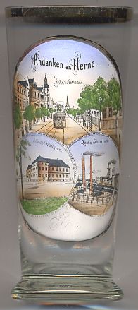
The top picture on glass no. 2633 shows a view of the street
 Bahnhofstraße
Castle Strünkede [bottom left] is amoated castle in Herne's city district of Baukau.
The lords of Strünkede were first mentioned in a document of 1142, the first document mentioning the castle dates from 1243.
Until 1767 the castle remained in the family of Strünkede. Since 1948 it is owned by the city of Herne.
The
The
The Zeche Shamrock [bottom right] was a coal mine in Herne.
The mining society Shamrock was founded in 1856 and was financed by Irish and Belgian investors. A a reference to the first mine within the cities boundaries,
Herne had included a shamrock in the city's coat of arms between 1897 and 1975.
In 1967 the mine was connected under ground to the mine General Blumenthal and since then was referred to only as mine shaft no. 11.
The Shamrock mine was closed in October 1967 and in its place a chemical plant was built (Chemische Werke Hüls).
Wanne
 Wanne, as a place name, is of relatively recent origin. During the Middle Ages, the largest settlement in this location was named Bickern.
Another historical town quarter, Crange, was elevated to a 'freiheit' (a market town) in 1484. Together with the communities of
Eickel, Holsterhausen and Röhlinghausen hese were placed in the newly created Amt (county or township) 'Wanne' in 1875, while before they had been part of the Amt Herne.
Following the rapid growth of industry in the second half of the 19th century, the communities grew equally rapidly. The Amt Wanne was placed in the district
Gelsenkirchen in 1885; in 1891 the Amt was partitioned into the Amt Wanne (Bickern, Crange and Röhlinghausen) and the Amt Eickel (Eickel and Holsterhausen).
In 1897 municipality of Bickern took on the name Wanne. Crange was merged with Wanne in 1906, while Holsterhausen merged with Eickel in 1910. Wanne and Eickel
were merged into the new city of Wanne-Eickel in 1926. In order to avoid being merged with Bochum, the city council of Wanne-Eickel decided to merge
with the neighbouring Herne; this was ofiicially executed on 1 January 1975. Wanne and Eickel now form two of the four city districts of Herne; however,
the name Wanne-Eickel is still used by the local population.
[https://de.wikipedia.org/wiki/Herne-Wanne]
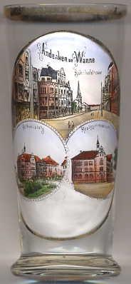
Bahnhoftraße of Wanne [left, no. 2886: top picture] received its name in 1912; before that it was named Cranger Straße. Renamed Hindenburgstraße in 1918
and Friedrich-Ebert-Straße in 1946 it was finally named Hauptstraße in 1947.
[http://www.herne.de/kommunen/herne/ttw.nsf/id/de_hauptstrasse]
Rathausplatz [left, no. 2886: bottom left picture] received its name in 1906.
The Rathaus (Town Hall) Wanne-Eickel was built in 1903–1904 as administration building for the Amt Wanne. It was inaugurated on
19 January 1905. Since December 1985 the building is listed as a historical monument.
[https://de.wikipedia.org/wiki/Rathaus_Wanne-Eickel]
Realgymnasium of Wanne [left, no. 2886: bottom right picture] today Gymnasium Eickel, was founded in 1903 and also incorporated
the former Protestant and Catholic Rectory Schools founded in 1886 and 1894, respectively. The new school building in Renaissance revival style
was opened in 1904.
[http://www.europese-bibliotheek.nl/en/Books/Wanne-Eickel_in_alten_Ansichten/100-130870/Article/6]
Wanne, as a place name, is of relatively recent origin. During the Middle Ages, the largest settlement in this location was named Bickern.
Another historical town quarter, Crange, was elevated to a 'freiheit' (a market town) in 1484. Together with the communities of
Eickel, Holsterhausen and Röhlinghausen hese were placed in the newly created Amt (county or township) 'Wanne' in 1875, while before they had been part of the Amt Herne.
Following the rapid growth of industry in the second half of the 19th century, the communities grew equally rapidly. The Amt Wanne was placed in the district
Gelsenkirchen in 1885; in 1891 the Amt was partitioned into the Amt Wanne (Bickern, Crange and Röhlinghausen) and the Amt Eickel (Eickel and Holsterhausen).
In 1897 municipality of Bickern took on the name Wanne. Crange was merged with Wanne in 1906, while Holsterhausen merged with Eickel in 1910. Wanne and Eickel
were merged into the new city of Wanne-Eickel in 1926. In order to avoid being merged with Bochum, the city council of Wanne-Eickel decided to merge
with the neighbouring Herne; this was ofiicially executed on 1 January 1975. Wanne and Eickel now form two of the four city districts of Herne; however,
the name Wanne-Eickel is still used by the local population.
[https://de.wikipedia.org/wiki/Herne-Wanne]
Bahnhoftraße of Wanne [left, no. 2886: top picture] received its name in 1912; before that it was named Cranger Straße. Renamed Hindenburgstraße in 1918
and Friedrich-Ebert-Straße in 1946 it was finally named Hauptstraße in 1947.
[http://www.herne.de/kommunen/herne/ttw.nsf/id/de_hauptstrasse]
Rathausplatz [left, no. 2886: bottom left picture] received its name in 1906.
The Rathaus (Town Hall) Wanne-Eickel was built in 1903–1904 as administration building for the Amt Wanne. It was inaugurated on
19 January 1905. Since December 1985 the building is listed as a historical monument.
[https://de.wikipedia.org/wiki/Rathaus_Wanne-Eickel]
Realgymnasium of Wanne [left, no. 2886: bottom right picture] today Gymnasium Eickel, was founded in 1903 and also incorporated
the former Protestant and Catholic Rectory Schools founded in 1886 and 1894, respectively. The new school building in Renaissance revival style
was opened in 1904.
[http://www.europese-bibliotheek.nl/en/Books/Wanne-Eickel_in_alten_Ansichten/100-130870/Article/6]
![[scale]](lineal.jpg) contact: webmaster
contact: webmaster