
|
|
| ČESKÁ REPUBLIKA | CZECH REPUBLIC |
| Moravskoslezský kraj | North Moravia and Silesia (Ostrava) region |
| Okres: Nový Jičín |
map →

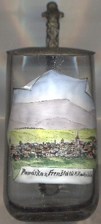 Frenštát pod Radhoštěm (German: Frankstadt unter dem Radhoscht) is situated at an elevation of 401 m
in the foothills of the Moravian-Silesian Beskids where the Bystrý stream joins the river Lubina, about 15 km southeast of the district town
Nový Jičín and about 31 km south of the regional capital, Ostrava.
The municipality has a population of about 10,800 (2021). The name suffix pod Radhoštěm refers to the mountain
Radhošť, which is located just 6 km south of the town on the border between the Ostrava and
Zlín regions.
Frenštát pod Radhoštěm (German: Frankstadt unter dem Radhoscht) is situated at an elevation of 401 m
in the foothills of the Moravian-Silesian Beskids where the Bystrý stream joins the river Lubina, about 15 km southeast of the district town
Nový Jičín and about 31 km south of the regional capital, Ostrava.
The municipality has a population of about 10,800 (2021). The name suffix pod Radhoštěm refers to the mountain
Radhošť, which is located just 6 km south of the town on the border between the Ostrava and
Zlín regions.
The village was founded between 1293 and 1318 in the course of the colonisation of the foothills of the Beskid mountains by the lord of
Šostýn (Schauenstein). Frankenstat was first mentioned in 1382. In 1437, the Šostýn domains were incorporated
into the Hukvaldy (Hochwald) domain, owned by the bishops of Olomouc (Olmütz). In 1781, Frankstadt obtained the
status of a town. After the end of manorialism, Frankenstadt in 1850 became an independent municipality in the district Mistek
(Frýdek-Místek). In 1888 the town was connected to the railway network by a section of the
Kaiser-Ferdinands-Nordbahn (for details see Bohumín). After World War I Frenštát became part of
Czechoslovakia, and in 1921 the suffix pod Radhoštěm was introduced. In 1961, Frenštát pod Radhoštěm
was attached to the district Nový Jičín.
[https://de.wikipedia.org/wiki/Fren%C5%A1t%C3%A1t_pod_Radho%C5%A1t%C4%9Bm]
![[scale]](lineal.jpg)