
|
|
| ÖSTERREICH | AUSTRIA |
| Bundesland: Niederösterreich | Lower Austria |
| Bezirk: Tulln |
map →

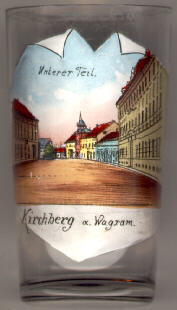 Kirchberg am Wagram is situated at an elevation of 224 m on the southern slope of the Wagram, the steep and fertile escarpment (10–30 m) north
of the river Danube extending from the river Kamp to the river March. The first mention in a document refers to the foundation of the church Sankt Stephan in 1014.
Sankt Stephan was also the name of the town until the beginning of the 15th century, when the name Kirchberg came into use.
Kirchberg must have had the status of a market town already in 1222. This status was confirmed by Emperor Friedrich III in 1493. During the Middle Ages,
Kirchberg am Wagram thrived as a trading place at the crossroads of important trade routes. In 1872, Kirchberg was connected to the Franz-Josephs-Bahn railroad
(Vienna, Tulln, Eggenburg, Gmünd, České Budějovice, Plzeň and Prague).
Today, one of the most important economic factors for the town is the
power plant of Altenwörth, the largest river power plant on the Danube.
Kirchberg am Wagram is situated at an elevation of 224 m on the southern slope of the Wagram, the steep and fertile escarpment (10–30 m) north
of the river Danube extending from the river Kamp to the river March. The first mention in a document refers to the foundation of the church Sankt Stephan in 1014.
Sankt Stephan was also the name of the town until the beginning of the 15th century, when the name Kirchberg came into use.
Kirchberg must have had the status of a market town already in 1222. This status was confirmed by Emperor Friedrich III in 1493. During the Middle Ages,
Kirchberg am Wagram thrived as a trading place at the crossroads of important trade routes. In 1872, Kirchberg was connected to the Franz-Josephs-Bahn railroad
(Vienna, Tulln, Eggenburg, Gmünd, České Budějovice, Plzeň and Prague).
Today, one of the most important economic factors for the town is the
power plant of Altenwörth, the largest river power plant on the Danube.
Further glasses in this collection show views from
Kirchberg (Saxony, Germany),
Kirchberg am Wechsel (Lower Austria) and
Kirchberg an der Jagst (Baden-Württemberg, Germany).
![[scale]](lineal.jpg)