
|
|
| ÖSTERREICH | AUSTRIA |
| Bundesland: Steiermark | Styria |
| Bezirk: Liezen |
map →

 Ramsau am Dachstein is situated between the Dachstein range of mountains in the north and the Enns valley in the south. While the Dachstein range contains peaks up to 2,995 m
and the towns of the Enns valley, such as Schladming, lie at around 700 m above sea level, the Ramsau plateau is a comparatively level piece of land at an elevation of around 1,100 m.
At approximately 75 km², the plateau is an exceptional geological feature in the rugged terrain of the Alps which is more usually characterized by high mountain ranges and narrow
valleys. The municipality of Ramsau am Dachstein is made up of several smaller villages, namely Leiten, Rössing, Ramsau, Schildlehen, Vorberg and Hirzegg. The overall population of the
municipality was recorded as 2,701 in the 2001 census.
Ramsau am Dachstein is situated between the Dachstein range of mountains in the north and the Enns valley in the south. While the Dachstein range contains peaks up to 2,995 m
and the towns of the Enns valley, such as Schladming, lie at around 700 m above sea level, the Ramsau plateau is a comparatively level piece of land at an elevation of around 1,100 m.
At approximately 75 km², the plateau is an exceptional geological feature in the rugged terrain of the Alps which is more usually characterized by high mountain ranges and narrow
valleys. The municipality of Ramsau am Dachstein is made up of several smaller villages, namely Leiten, Rössing, Ramsau, Schildlehen, Vorberg and Hirzegg. The overall population of the
municipality was recorded as 2,701 in the 2001 census.
The name Ramsau was first recorded as Ramsowe in a document dated to around 1120. Important landowners during the feudal period and beyond were the abbey of Admont and the archabbey of St. Peter's in Salzburg. After the events of the Reformation and the Counter-reformation of the 16th century, the relatively secluded Ramsau emerged as one of the few thoroughly Protestant communities in Austria; something which it remains to this day. As early as the 15th century, the area established a tradition in the manufacture of loden, a thick cloth used in the traditional dress of the wider region. With the advent of commercial tourism in the late 19th century the area gained another steady source of income.
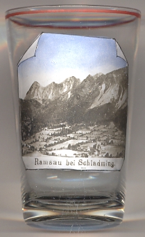
The  Hoher Dachstein [background] is the second highest mountain in the Northern Limestone Alps. It is situated at the border of Upper Austria
and Styria in central Austria, and is the highest point in each of those states. Parts of the massif also lie in the state of Salzburg, leading to the mountain being referred to as the
Drei-Länder-Berg ("three-state mountain"). The Dachstein massif covers an area of around 20 by 30 km with dozens of peaks above 2,500 m, the highest of which are in the southern and
south-western areas. Seen from the north, the Dachstein massif is dominated by the glaciers with the rocky summits rising beyond them. By contrast, to the south, the mountain drops almost
vertically to the valley floor. The south face of the Dachstein massiv, depicted here, is marked by three summits: from west to east (left to right):
Torstein (2,948 m, first climbed in 1819), Mitterspitz (2,925 m, first climbed in 1872) and Hoher Dachstein (2,995 m, first climbed in 1834).
The northern part of the massif can be reached by cablecar from Obertraun: the first part from the valley station at 600 m to Schönbergalm, 1,340 m,
with its two famouos caves, the Giant Ice Cave and the Mammoth Cave, opened in 1951, the second part to the Krippenstein at 2,100 m opened in 1956, the third part down to Gjaidalm
at 1,738 m opened in 1961; the final fourth part, however, never was built.
The Dachstein-Südwandbahn (South Face Cable Car, opened in 1969) leads from Ramsau am Dachstein (valley station Türlwandhütte at 1,702 m) to the Hunerkogel (2,700 m) without
any supports in between.
Hoher Dachstein [background] is the second highest mountain in the Northern Limestone Alps. It is situated at the border of Upper Austria
and Styria in central Austria, and is the highest point in each of those states. Parts of the massif also lie in the state of Salzburg, leading to the mountain being referred to as the
Drei-Länder-Berg ("three-state mountain"). The Dachstein massif covers an area of around 20 by 30 km with dozens of peaks above 2,500 m, the highest of which are in the southern and
south-western areas. Seen from the north, the Dachstein massif is dominated by the glaciers with the rocky summits rising beyond them. By contrast, to the south, the mountain drops almost
vertically to the valley floor. The south face of the Dachstein massiv, depicted here, is marked by three summits: from west to east (left to right):
Torstein (2,948 m, first climbed in 1819), Mitterspitz (2,925 m, first climbed in 1872) and Hoher Dachstein (2,995 m, first climbed in 1834).
The northern part of the massif can be reached by cablecar from Obertraun: the first part from the valley station at 600 m to Schönbergalm, 1,340 m,
with its two famouos caves, the Giant Ice Cave and the Mammoth Cave, opened in 1951, the second part to the Krippenstein at 2,100 m opened in 1956, the third part down to Gjaidalm
at 1,738 m opened in 1961; the final fourth part, however, never was built.
The Dachstein-Südwandbahn (South Face Cable Car, opened in 1969) leads from Ramsau am Dachstein (valley station Türlwandhütte at 1,702 m) to the Hunerkogel (2,700 m) without
any supports in between.
[https://en.wikipedia.org/wiki/Ramsau_am_Dachstein, https://en.wikipedia.org/wiki/Dachstein, https://de.wikipedia.org/wiki/Dachsteinmassiv,
https://de.wikipedia.org/wiki/Dachsteinseilbahn, https://de.wikipedia.org/wiki/Dachstein-Südwandbahn]
![[scale]](lineal.jpg)