
|
|
| ÖSTERREICH | AUSTRIA |
| Bundesland: Steiermark | Styria |
| Bezirk: Bruck-Mürzzuschlag |
map →

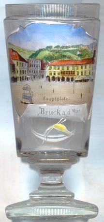
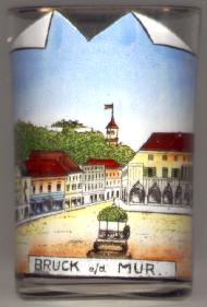
Bruck an der Mur is situated at an elevation of 468 m at the confluence of the rivers Mur and Mürz. Bruck an der Mur is the capital of the district Bruck-Mürzzuschlag (until 31 December 2012 of the district Bruck an der Mur). The municipality has a population of about 12,500 (2012).
 The earliest known written document that mentions ad pruccam dates from AD 860. Prukka here refered to today's town quarter of St. Rupprecht.
The settlement that was located at today's old town centre in those times was named muorica kimundi (Mürzgemünd). The settlement was owned by the archbishopric
of Salzburg until 1074 when the town came in possession of the monastery of Admont. Due to its location Bruck soon became an
important trading place. In 1263 King Ottokar II of Bohemia (since 1261 also Duke of Styria) founded the present town core and built its fortifications.
In 1277 the German King Rudolf I confirmed the privileges of a town which had already been mentioned in documents as early as 1263.
In 1748 Styria was subdivided into five administrative areas (Kreise, 'circles') with Bruck as the capital of the district of the same name. The districts were rearranged in 1855 but
Bruck remained the capital of the district Bruck.
On 1 January 2013 the former districts Bruck an der Mur and Mürzzuschlag were merged into the new district Bruck-Mürzzuschlag;
the capital of the new district is Bruck an der Mur.
The earliest known written document that mentions ad pruccam dates from AD 860. Prukka here refered to today's town quarter of St. Rupprecht.
The settlement that was located at today's old town centre in those times was named muorica kimundi (Mürzgemünd). The settlement was owned by the archbishopric
of Salzburg until 1074 when the town came in possession of the monastery of Admont. Due to its location Bruck soon became an
important trading place. In 1263 King Ottokar II of Bohemia (since 1261 also Duke of Styria) founded the present town core and built its fortifications.
In 1277 the German King Rudolf I confirmed the privileges of a town which had already been mentioned in documents as early as 1263.
In 1748 Styria was subdivided into five administrative areas (Kreise, 'circles') with Bruck as the capital of the district of the same name. The districts were rearranged in 1855 but
Bruck remained the capital of the district Bruck.
On 1 January 2013 the former districts Bruck an der Mur and Mürzzuschlag were merged into the new district Bruck-Mürzzuschlag;
the capital of the new district is Bruck an der Mur.
The  Kornmesserhaus [right],
named after its founder, the iron dealer Pankraz Kornmess, was built 1499–1505
strongly influenced by Venetian architecture
and is considered one of the finest examples of late Gothic style in Central Europe.
Kornmesserhaus [right],
named after its founder, the iron dealer Pankraz Kornmess, was built 1499–1505
strongly influenced by Venetian architecture
and is considered one of the finest examples of late Gothic style in Central Europe.
The Eiserner Brunnen
The Uhrturm
Today, the main square is called Koloman-Wallisch-Platz after the leader of the
Austrian Social Democrats who was executed during the Civil War in 1934.
See also:
Bruck an der Leitha
Schloss Bruck in Lienz
![[scale]](lineal.jpg)