
|
|
| DEUTSCHLAND | GERMANY |
| Bundesland: Freistaat Sachsen | Saxony |
| Landkreis: Vogtlandkreis |
map →

Plauen is situated at an elevation of 412 m on the river Weiße Elster in the Vogtland region of Saxony. The first mention in a document (vicus plawe) dates from 1122. In 1224, Plauen obtained the status of a town. Clothmaking and weaving were the main economic factors in the 15th and 16th century. In 1602, Plauen became the capital town of the Vogtland district. The opening of the railway line (Sächsisch-Bayrische Eisenbahn), which connected Plauen to Hof in Bavaria (1848) and to Leipzig via Reichenbach im Vogtland, Werdau, Crimmitschau and Altenburg (1851), initiated the industrial development of Plauen. Manufacturing systems engineering started with the construction of the first knitting machine in 1881 and the first rotary printing machine in 1889. The largest number of inhabitants was reached in 1912 (128,000). In 1945, about 75% of the city were destroyed. Today, Plauen has a population of about 72,000.
 The
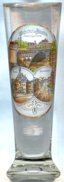
The  Friedrich-August-Brücke (today Friedensbrücke) [left, no. 872: top]
across the Syra stream was built in 1903–1905 and was opened by Friedrich August III (1865–1932), last King (1904–1918) of Saxony.
Until 1945 it was the world's largest stone arch bridge (span 90 m, height 18 m, width 17 m). Today, it is the largest of its kind in Europe.
In 1945, after World War II, the bridge was named for Friedrich Ebert (1871–1925), German socialist leader and president of the
post-World War I Weimar Republic.
The reconstruction of the bridge took until 1949. Since 1973, its name is Friedensbrücke (Peace Bridge).
Friedrich-August-Brücke (today Friedensbrücke) [left, no. 872: top]
across the Syra stream was built in 1903–1905 and was opened by Friedrich August III (1865–1932), last King (1904–1918) of Saxony.
Until 1945 it was the world's largest stone arch bridge (span 90 m, height 18 m, width 17 m). Today, it is the largest of its kind in Europe.
In 1945, after World War II, the bridge was named for Friedrich Ebert (1871–1925), German socialist leader and president of the
post-World War I Weimar Republic.
The reconstruction of the bridge took until 1949. Since 1973, its name is Friedensbrücke (Peace Bridge).
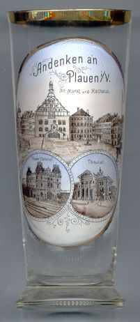
 The old town hall [far left, no. 872: bottom left; left, no. 4438 and right, no. 1141: top]
is a popular landmark of Plauen and was built in 1508 in place of an older town hall that was first mentioned in 1382. The mechanical clock and the
Renaissance façade dates from 1548. The new town hall and its tower (64 m high) were built next to it in 1912–1923 [these are not
depicted on the glasses].
The old town hall [far left, no. 872: bottom left; left, no. 4438 and right, no. 1141: top]
is a popular landmark of Plauen and was built in 1508 in place of an older town hall that was first mentioned in 1382. The mechanical clock and the
Renaissance façade dates from 1548. The new town hall and its tower (64 m high) were built next to it in 1912–1923 [these are not
depicted on the glasses].
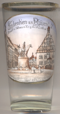
The monument for King Albert (b. 1828, r. 1873–1902) was created by the sculptor Carl Seffner and was
inaugurated in 1907, five years after Albert's death. The bronze-cast equestrian statue has been missing since World War II. In its place, a fountain
with several bronze figures was created in 2007 by the sculptor Norbert Marten.
[https://www.stadtwikidd.de/wiki/K%C3%B6nig-Albert-Denkmal]
The historic building of Plauen's main railway station Oberer Bahnhof [right, no. 1141: bottom left]
was destroyed in 1945. The present modern station complex was built in 1971–1973.
The Stadttheater [right, no. 1141: bottom right] was built in 1899–1900. The theatre was restored
in1935, 1978/79 and 1992–1994.
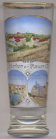
The new town hall [left, no. 2238: bottom right picture: left building]
was built in 1912. The building to the right of it is labeled
Sparkasse
The bottom left picture on glass no. 2238 [left] shows the
Elstertalbrücke
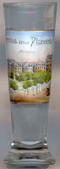
The square Albertplatz [left, no. 1481] was named for King Albert of Saxony (1828–1902, king 1873–1902).
During the time of the German Democratic Republic (1945–1990) the place was renamed for the Red Army (Platz der Roten Armee). Most of the
old buildings surrounding the square have been destroyed during the war, or have been demolished and replaced by modern buildings after the war.
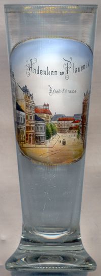
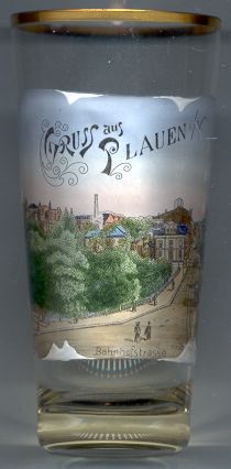
The Bahnhofstraße [right, no. 1750, and below, no. 1837; also above, no. 872: bottom right picture]
was created in 1837/48.
![[scale]](lineal.jpg)