
|
|
| DEUTSCHLAND | GERMANY |
| Bundesland: Brandenburg | |
| Landkreis: Elbe-Elster |
map →
Finsterwalde is situated at an elevation of 108 m in the Elbe-Elster district of southern Brandenburg. With a population of about 19,000 (2004) it is the largest town of the district, although not the seat of the district's administration (this is Herzberg/Elster).
 Finsterwalde began to develop next to a stronghold that had been founded by Slavic people. The oldest written mention
of Vynsterwalde dates from 1282. In 1301 it was first mentioned as 'oppidum', a market town.
The oldest secure mention of Finsterwalde as a town is found in a document of 1336.
Until the mid-15th century, the old stronghold was enlarged into a castle which was the seat of robber barons.
After 1437 the castle was transformed into a residential castle. The remodeling in Renaissance style was finally completed
after 1533. Clothmaking became the most imoprtant factor for the town's economy during that period. In 1625
Finsterwalde became a personal property of Elector Johann Georg I of Saxony. However, the castle did not become
a residence but was used for administrative purposes of the Electorate, between 1652 and 1738 of those of
the collateral line of Saxe-Merseburg. During of the Thirty Years' War (1618–1648) Finsterwalde was looted in 1642.
This was severe blow for the town and it took decades until it could flourish again. In 1815, after the Congress of
Vienna, Finsterwalde became part of the Kingdom of Prussia. During the 19th century
it was again cloth-making that became the centre of the industrial activities of the town.
Finsterwalde began to develop next to a stronghold that had been founded by Slavic people. The oldest written mention
of Vynsterwalde dates from 1282. In 1301 it was first mentioned as 'oppidum', a market town.
The oldest secure mention of Finsterwalde as a town is found in a document of 1336.
Until the mid-15th century, the old stronghold was enlarged into a castle which was the seat of robber barons.
After 1437 the castle was transformed into a residential castle. The remodeling in Renaissance style was finally completed
after 1533. Clothmaking became the most imoprtant factor for the town's economy during that period. In 1625
Finsterwalde became a personal property of Elector Johann Georg I of Saxony. However, the castle did not become
a residence but was used for administrative purposes of the Electorate, between 1652 and 1738 of those of
the collateral line of Saxe-Merseburg. During of the Thirty Years' War (1618–1648) Finsterwalde was looted in 1642.
This was severe blow for the town and it took decades until it could flourish again. In 1815, after the Congress of
Vienna, Finsterwalde became part of the Kingdom of Prussia. During the 19th century
it was again cloth-making that became the centre of the industrial activities of the town.
 The large
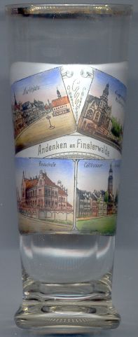
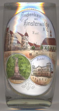
  Market Square (Marktplatz) [left, no. 2014: top left picture; right,
no. 3254: top] marks the centre
of the old town. The Baroque Town
Market Square (Marktplatz) [left, no. 2014: top left picture; right,
no. 3254: top] marks the centre
of the old town. The Baroque Town
The top right picture on glass no. 2014 [left] and the bottom left picture on glass no. 3254
[right] show the soldiers' entrance
The Secondary Modern School (Realschule) [left, no.( 2014: bottom left]
was built in 1904–1905. Between 1945 and 1993 the building was used as a military hospital by the Soviet Army.
After extensive renovation works it is today used again as a school.
The bottom right picture on glass no. 2014 [left] shows a view of
Cottbusser water
The railway station [right, no. 3254: bottom right]
was opened in 1866 and served the railroad from Berlin. In 1867 the line was continued to
Görlitz. The station building was inaugurated in 1870. North of this station,
another station building for the line to Großenhain was opened in 1873; however,
the that station building was already closed in 1880 but is still in use for the station's administration.
Another station building for Spreewald followed in 1893 (dismantled in 1983). Plans to enlarge
the station were already made in 1927; however, they were not carried out due to the Great Depression. The station was
destroyed during World War II in 1945. Although only provisorily repaired, a new station building was only built
in 1970–1978.
[https://de.wikipedia.org/wiki/Bahnhof_Cottbus]
![[scale]](lineal.jpg)