
|
|
| ÖSTERREICH | AUSTRIA |
| Bundesland: Niederösterreich | Lower Austria |
| Bezirk: Lilienfeld |
map →

 Türnitz is situated at an elevation of 463 m in the valley of the river Türnitz (Türnitzer Traisen) in southern Lower Austria.
The municipality has a population of about 2,000 (2008).
The cadastral districts of Türnitz are Anthofrotte, Außerfahrafeld, Lehenrotte, Moosbach, Pichlrotte,
Raxenbachrotte, Schildbachrotte, Steinbachrotte, Traisenbachrotte, Türnitz and Weidenaurotte.
Türnitz is situated at an elevation of 463 m in the valley of the river Türnitz (Türnitzer Traisen) in southern Lower Austria.
The municipality has a population of about 2,000 (2008).
The cadastral districts of Türnitz are Anthofrotte, Außerfahrafeld, Lehenrotte, Moosbach, Pichlrotte,
Raxenbachrotte, Schildbachrotte, Steinbachrotte, Traisenbachrotte, Türnitz and Weidenaurotte.
The place is one of the oldest inhabited places of the area. The name is of Slavic origin and refers to difficult to access, remote place. The original Slavic population was later assimilated by German-speaking settlers in the 10th and 11th centuries. The earliest mention of the name Durnitze dates from 1209 and is found in a document, which transfers the domain to the monastery of Lilienfeld. In the 13th century pilgrimages to Mariazell began to become popular and Türnitz began to grow as an important place of rest for the many pilgrims travelling on the 'Via sacra' (Vienna, Perchtoldsdorf, Brunn am Gebirge, Maria Enzersdorf, Hinterbrühl, Gaaden, Sulz im Wienerwald, Heiligenkreuz, Mayerling, Alland, Nöstach, Hafnerberg, Hocheck, Altenmarkt an der Triesting, Kleinmariazell/Altenmarkt, Thenneberg, Kaumberg, Hainfeld, Rohrbach an der Gölsen, Sankt Veit an der Gölsen, Marktl, Lilienfeld, Türnitz, Siebenbrunn, Annaberg, Joachimsberg, Sankt Sebastian, Mariazell). By 1371 Türnitz had obtained the status of a market town. The first wire and copper works were mentioned in 1715. The first hammer mill for the production of scythe blades opened in 1825. Further hammer mills opened in 1846, 1855, and 1865 and made Türnitz an important centre of scythe production. The opening of a spa for cold water cures initiated a gradual change from an industrial community to a local centre for tourism. Since the mid-20th century winter tourism has become a major source of income for the community.
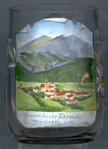
The  parish church Sankt Martin [background centre]
was built in laet Gothic style in the 15th century. The parish itself was created in 1217 and since 1249 belongs to the monastery of Lilienfeld.
The north nave of the church was added in 1509. The west tower was erected during the Baroque period. A vestibule in Classicist
style was added in 1833. The tower roof was renewed in 1994. Most of the interior decorations were created around 1760 in Rococo style
The main altar was made of grey marble from Türnitz in 1768. The octogonal baptismal font dates from the late Gothic period.
parish church Sankt Martin [background centre]
was built in laet Gothic style in the 15th century. The parish itself was created in 1217 and since 1249 belongs to the monastery of Lilienfeld.
The north nave of the church was added in 1509. The west tower was erected during the Baroque period. A vestibule in Classicist
style was added in 1833. The tower roof was renewed in 1994. Most of the interior decorations were created around 1760 in Rococo style
The main altar was made of grey marble from Türnitz in 1768. The octogonal baptismal font dates from the late Gothic period.
The mountain in the background of the picture on glass no. 1531 is the
Eibel (Eibl)
![[scale]](lineal.jpg)