
|
|
| ČESKÁ REPUBLIKA | CZECH REPUBLIC |
| Olomoucký kraj | Olomouc region |
| Okres: Přerov |
map →
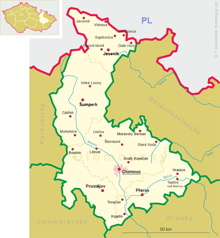
 Hranice (German: Mährisch-Weißkirchen) is situated at an elevation of 250 m in the
Přerov district, about 37 km east of Olomouc in the foothills
of Oderskévrchy (Odra mountains) between the rivers Velička and Ludina where these flow into the Bečva
river. The municipality has a population of about 18,400 (2017). The official name of the municipality is Hranice;
however, there are several other places of the name name in the Czech Republic (Hranice in district
České Budějovice and Hranice in district Cheb, as
well as the town parts or cadastral districts named Hranice in Karviná, Nový
Knín, Maleč, Rokytnice nad Jizerou and Slavošov. The railway station of
Hranice is named Hranice na Moravě (Hranice in Moravia).
Hranice (German: Mährisch-Weißkirchen) is situated at an elevation of 250 m in the
Přerov district, about 37 km east of Olomouc in the foothills
of Oderskévrchy (Odra mountains) between the rivers Velička and Ludina where these flow into the Bečva
river. The municipality has a population of about 18,400 (2017). The official name of the municipality is Hranice;
however, there are several other places of the name name in the Czech Republic (Hranice in district
České Budějovice and Hranice in district Cheb, as
well as the town parts or cadastral districts named Hranice in Karviná, Nový
Knín, Maleč, Rokytnice nad Jizerou and Slavošov. The railway station of
Hranice is named Hranice na Moravě (Hranice in Moravia).
The settlement was allegedly founded in 1162; however, the document of 1169 mentioning it later proved to be a falsification. However, the foundation must have taken place some time towards the end of the 12th or beginning of the 13th century when the Benedictine abbey of Rajhrad (Reigern) began to colonise the area on behalf of the duke of Bohemia. The name Hranice actually means 'border'. After the village in 1276 had been elevated to a town, the name Alba ecclesia ('white church') came in use and became the origin of the German name, Weißkirchen. It is not known whether this actually to a whitewashed church building or rather to the white habit of the Premonstratensian monks of Hradisko monastery, who had been in possession of the area since 1222. In 1292 Hranice obtained the full privileges of a town. In the first half of the 16th century, Hranice was in possession of the lords of Pernštejn. After the Battle of the White Mountain (today part of Prague) in 1621, the estates were given to the bishop of Olomouc, count Dietrichstein. The Dietrichstein remained in its possession up until the 19th century. In 1847 Hranice was connected to the railroad system in 1847 (Kaiser-Ferdinands-Nordbahn from Vienna to Kraków; see Bohumín for further informtion). After the abolition of patrimonialism, the municipality was founded in 1850 and became the seat of a district. Today, Hranice is part of the district Přerov.
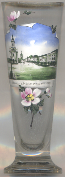
The Baroque and Classicist  church of the Decapitation of St. John the Baptist
[left, no. 3482: left] was built in 1754–1763 and was consecrated in 1764. In 1879, the vaulting was decorated with
paintings, which, however, were removed during a renovation in the 1970s.
church of the Decapitation of St. John the Baptist
[left, no. 3482: left] was built in 1754–1763 and was consecrated in 1764. In 1879, the vaulting was decorated with
paintings, which, however, were removed during a renovation in the 1970s.
The old town hall [, no. 3482: far background] goes back to the Gothic period. The
Gothic hall with an impressive vaulting was finished in 1528. The Renaissance portal dates from 1544. The tower was
added in 1571. Modifications were made in 1869 and at the beginnning of the 20th century. In 1998 the municipal
administration moved into Hranice castle; the old town hall since then is used as municipall museum, library and school.
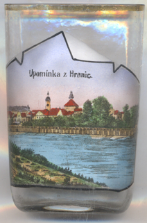
A natural sight near Hranice is the Hranice Abbyss, the deepest flooded pit cave in the world. It is a karst sinkhole
created by the collapse of the roof cave, which was eaten away by warm carbonic acidulous spring water in limestone.
As of 2016, the confirmed depth reached by a diving robot, is 473 m (404 m under the water level). The
assumed depth is 800–1200 m. (Another glass of this collection shows the Macocha
Abyss north of Brno.)
[https://de.wikipedia.org/wiki/Hranice_na_Moravě, https://en.wikipedia.org/wiki/Hranice,
https://cs.wikipedia.org/wiki/Hranice_(okres_Přerov);
http://mic.hranet.cz/cs/historie-a-pamatky/stavebni-pamatky/farni-kostel-steti-sv-jana-krtitele.html;
http://mic.hranet.cz/cs/historie-a-pamatky/stavebni-pamatky/stara-radnice.html]
![[scale]](lineal.jpg)